About the Plan
A Harbor Plan is a state-approved document establishing community goals, standards and policies to guide public and private land use along harbors.
- Allows for Chapter 91 standards to be tailored to implement a community vision for the waterfront
- Relies on input from the public and from an advisory committee
- Builds from previous Harbor Plans and promotes long-range waterfront planning goals
- Administered at the state level by the Office of Coastal Zone Management (CZM)
- Changes must be consistent with Massachusetts tidelands policy
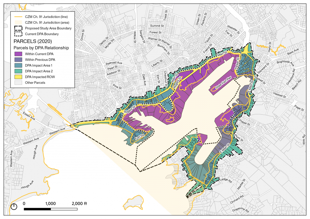
While Gloucester’s current Municipal Harbor Plan/Designated Port Area Master Plan (MHP/DPA MP) was approved on December 14, 2014 with a ten year expiration, we believe our evolving harbor economy faces continued pressures (1) to its commercial fishing operations from changes in fisheries management and global competition, and (2) to its existing and aging infrastructure from the risks associated with climate change and rising tides. We also believe that our harbor economy is poised to capitalize on new “blue economy” opportunities in fisheries, marine research and biotechnology, and ocean and seafood product development.
City Staff:
- Mayor Greg Verga
- Christopher Sicuranza – Assistant to CAO
- Gregg Cademartori – Planning Director
- Jill Cahill – Community Development Director
- Gemma Wilkens – Planner
- Thomas Ciarametaro – Harbormaster
- Al Cottone – Fisheries Commission Director
- Michael Hale – Director of Public Works
Harbor Plan Committee
- Rick Noonan – Planning Board Chair
- John McCarthy – City Council Liaison
- Tony Gross – Waterways Board Chair
- Mark Ring – Fisheries Commission Chair
- Tom Balf – Economic Development & Industrial Corporation Member
- Katie Kahl – Citizen / Research Representative, Extension Assistant Professor of Sustainable Fisheries & Coastal Resilience at UMass Amherst
- Vito Giacalone – Citizen / Industry Representative, Fisherman, Former Policy Director for the Northeast Seafood Coalition, and President of the Gloucester Fishing Community Preservation Fund.
- Tessa Browne – Citizen / Industry Representative, Co-owner Cape Ann Lobstermen Co-op
Consultant Team
- Utile – Urban Planning and Design
- Tetra Tech & Fort Point Associates, Inc. – Chapter 91, Waterfront Infrastructure and Operations Specialists
- Ninigret Partners – Economic Analysis
- Woods Hole Group – Resiliency Advisory
- Brown Richardson + Rowe – Landscape Advisory
Baseline Assessment and Economic Strategy: Jun 2021 – Oct 2021
Evaluate the State Regulatory Environment: Aug 2021 – Dec 2021
Update the MHP and DPA Master Plan: Jan 2022 – Jan 2023